Rural Innovation
The Sheep Farmers Using Satellites to Boost Yields
Outback sheep stations are turning to satellite imagery and AI-driven data analysis to monitor pastures, improve flock health, and plan better grazing strategies amid climate uncertainty.
2025-06-08 • By Hamish Kaur
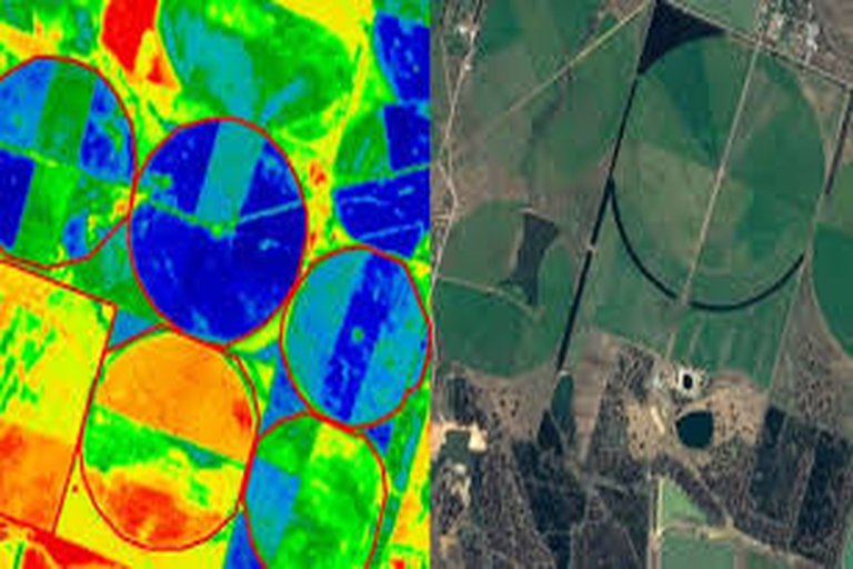
Sheep graziers in western Victoria are embracing satellite technology in a bid to boost productivity and cope with a changing climate. Using space-based imaging and AI tools, farmers are monitoring pasture quality, tracking animal movement, and making smarter grazing decisions.
Peter Daley, who runs a 1,200-head Merino farm near Hamilton, logs into his satellite dashboard each morning. 'I can see where the grass is thinnest, how much biomass is left, and even get alerts if mobs stray too far,' he explains.
The satellite data is paired with paddock sensors and GPS ear tags on livestock, enabling real-time insights. This helps reduce overgrazing, improves soil recovery, and allows farmers to rotate flocks more efficiently.
During the recent dry season, Daley used the system to identify underutilized pasture and avoided costly supplemental feeding. 'It paid for itself in three months,' he says.
Tech companies supplying these systems are scaling up quickly. Adoption rates have doubled since last year, spurred by subsidies and rising input costs. Some companies now bundle weather forecasts, satellite feeds, and AI into one mobile platform.
Researchers from Deakin University are also collaborating with farmers to develop predictive tools that anticipate pasture regrowth and animal weight gain. The result? Smarter farms, healthier flocks, and a tech-savvy new generation of sheep farmers.